Utility Network GIS Software
Contact us:
TEL: +086-010-50951355 / FAX:+86-010-50951352
Email : cathy@souvr.com / Frank@souvr.com / Robin@souvr.com / sales@souvr.com
Details
Related
Consulting
※Product Overview※
Utility Network GIS Software
Map and manage your electric, gas, water, wastewater, or district energy network with Bentley OpenUtilities Map. Save time and money when you maintain your network model in an affordable, full-featured utilities-specific GIS. Improve network management with reports and analysis such as network tracing, leak detection, and outage planning. Increase enterprise efficiency when you publish, manage, and view precise network maps using the embedded power of Bentley Map.
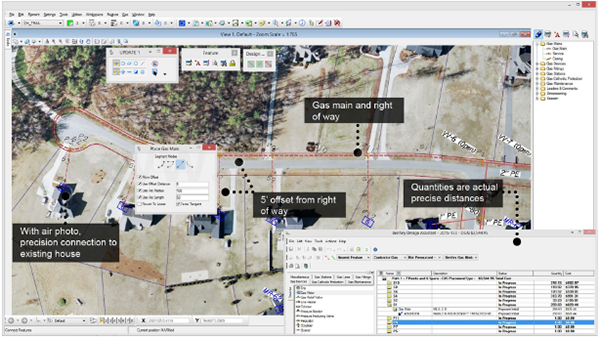
Enhance your network operations and management with a complete mapping and decision support solution. With Bentley OpenUtilities Map you can:
• Reduce the cost to implement and maintain your network information with a GIS that scales to your needs
• Quickly perform edits and simple layouts with network connectivity and topology tools
• Make faster and better decisions using network analysis and reporting tools to locate, review, and trace assets
• Improve service proactively by using an outage planner to assess impacts of field work and notify customers
• Reduce operations losses with tools to analyze and locate pipe leaks
• Reduce the cost and deployment time of your GIS with pre-configured data models
• Reduce total software costs by consolidating all of your network models in a single GIS
CAPABILITIES
Analyze and visualize utilities networks
Use GIS tools to create buffers, overlays, joins, thematic maps, dynamic labels, reports, and queries. Perform radial, upstream/downstream, shortest/multiple/redundant path traces for flow, conduit, and cathodic protection networks. Analyze and report on leaks for an area or the entire network.
Configure utilities network models and rules
Tailor out-of-the-box commodity-specific data models using simple meta data-based tools to create and manage data structures. Define compatible units with material and labor costs by job type and service region. Define design, symbology, and compatible unit rules to match your company standards.
Design district energy networks
Create, manage, analyze, estimate costs, and report on as-built asset information and design plans for extensions, repairs, renewals, and maintenance activities. Layout single, two-pipe, and multi-pipe networks for steam-based and water-based district energy systems. Achieve engineering-grade precision with MicroStation-based smart placement and editing.
Design electric distribution networks
Layout your primary, secondary, and public lighting networks. Achieve engineering-grade precision with MicroStation-based smart placement and editing. Design above- and below-ground network assets with detailed models of conduits and their cables. Define rules to ensure designs adhere to standards.
Design gas distribution networks
Layout main and service pipe networks as well as cathodic protection networks. Achieve engineering-grade precision with MicroStation-based smart placement and editing. Export layouts to other Bentley products to model and analyze the performance of your network design.
Design wastewater networks
Layout sewer, storm, and combined sewer/storm networks. Achieve engineering-grade precision with MicroStation-based smart placement and editing. Use 2D profile tools to check elevation grades. Export layouts to other Bentley products to model and analyze the performance of your network design.
Design water distribution networks
Layout main and lateral networks. Achieve engineering-grade precision with MicroStation-based smart placement and editing. Use 2D profile tools to check elevation grades and find preferred routing. Export layouts to other Bentley products to model and analyze the performance of your network design.
Maintain utilities network models and maps
Employ a full-featured utilities GIS based on the proven Bentley Map platform. Speed edits with intelligent GIS features and automated tools that apply your standards and business rules. Use the tight integration between your design system and GIS to avoid rework and ensure accurate as-built status.


