3D Geotechnical Groundwater Flow Software
Contact us:
TEL: +086-010-50951355 / FAX:+86-010-50951352
Email : cathy@souvr.com / Frank@souvr.com / Robin@souvr.com / sales@souvr.com
Details
Related
Consulting
※Product Overview※
3D Geotechnical Groundwater Flow Software
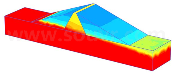
Go beyond the default options of steady-state groundwater flow analysis of PLAXIS with the PLAXIS 3D PlaxFlow add-on module. Simulate the unsaturated, time-dependent, and anisotropic behavior of soil with PLAXIS 3D PlaxFlow. Simultaneously calculate changes in pore pressures and deformation by performing a fully-coupled flow-deformation analysis. Plus, the Flow-only mode excludes displacements and stresses from the calculation if you are only interested in groundwater flow, making this application easier to use.

CAPABILITIES
Access predefined properties for unsaturated soil behavior
Take advantage of various predefined properties to define the unsaturated soil behavior, according to common soil classification systems such as Hypres, USDA, and Staring. Predefined data sets for the Van Genuchten and Approximate Van Genuchten model are available for all types of soil. For experts on groundwater flow modeling, Van Genuchten model parameters can be entered manually, or user-defined relationships between groundwater head, permeability, and saturation can be entered.
Assign time dependent flow boundary conditions
Assign time dependent variation or fluxes to water levels, model boundaries, or soil boundaries to simulate various complex hydrological conditions. The input of the time dependant properties is based on harmonic, linear, or table functions. This allows seasonal variations of river water levels behind embankments and their effect on the overall slope stability to be modeled. Precipitation, wells, and drains can be included in the model, allowing pumping tests or other hydrological applications to be modeled.
