HOT
 Production-Quality Lenses Directly from SLA 3D P…
 Forging Ahead with Solar Energy and GibbsCAM CNC…
 GibbsCAM Software Helps Race-Team Mechanics Beco…
 Metro Aerospace Introduces 3D Printed Part for F…
 GibbsCAM Enables Rover Exploration Vehicle Parts…
 Designing a Custom Boot for an Injured Penguin
 Asano Uses Geomagic 3D Scan Software to Drive In…
Winery Tops Off Tour with 3D Printed Map of Vineyard
Wine aficionados already know: the environment in which wine grapes grow impacts the final characteristics of the wine. Some subtly, some not so subtly. This element is known as terroir, a term that describes the complete natural environment from which a wine comes, including the climate and topography all the way down to the soil. These variables are anything but inconsequential to the flavor, color and body of the wine, and can be fascinating to learn about. Yet short of walking through a vineyard with surveying poles and kneeling to rub earth between your fingers, it can be challenging to get a comprehensive picture of terroir to fully appreciate the nuances at play in your glass.

This was a problem for Ten Minutes by Tractor, a winery on the Mornington Peninsula, Australia, that wanted to give its patrons a deeper understanding of its wines. Ten Minutes by Tractor is made up of three vineyards located ten minutes apart with widely different environmental characteristics that deliver vastly distinctive wines. The winery’s goal is to add value to its wine tour experience wherever possible by sharing its knowledge of wine making with its visitors. Yet verbally explaining the impact and differences in terroir proved minimally engaging without a visual reference. The winery needed a way to clearly communicate the contributions of the region to its wines that was accessible and effective.
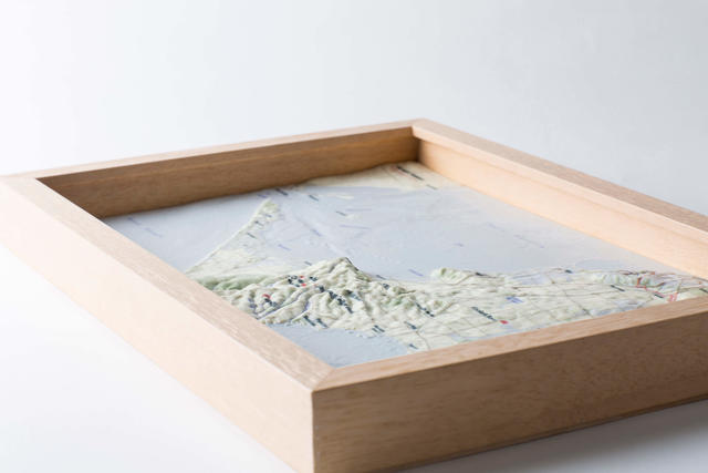
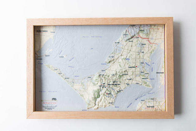
vW Maps, a trusted publisher of Australian wine regions, offered a solution and worked with the vineyard to create a digital 3D appearance model of the terrain. Using a scaled representation, the winery could show visitors the spatial relationship of the vineyards to one another as well as the interplay of environmental features that were responsible for creating distinctive character among the wines. vW Maps further enlisted 3D Systems’ On Demand Manufacturing services to transform the 3D data into a 3D printed appearance model at 1:160,000 scale with a five-fold elevation exaggeration. The final 3D printed models could then be examined and discussed as a memorable part of the cellar door experience.
Designing a 3D map of vineyard terrain
vW Maps took great care to merge and adapt graphic and cartographic design elements to get an effective mix of terrain selection, generalization and simplification with the right typography, color and balance. The resulting representation focuses viewer attention on the vineyards, terrain and most important landmarks. This allows cellar door staff at Ten Minutes by Tractor to easily reference and explain the complicated factors of terroir over a scaled appearance model of the terrain that is distinctive, appealing and easy to read. The map also helps cement the cellar door experience in visitors’ minds as a unique learning aid and conversation piece that stands out from other wineries in the region.

According to vW Maps Owner Martin von Wyss, although the appearance model design was digital in origin, “The terrain model is tangible and accessible when placed on the tasting bench next to a glass of wine, and it makes the geography of wine fun, engaging and easy to understand.”
Through an examination of the “Terroir Explainer,” as von Wyss calls the model, winery customers gain an understanding of the vineyards’ physical conditions, such as elevation, slope, aspect, and drainage. The cellar door staff supplements the 3D printed model with additional information about soil and climatic conditions to complete the picture of what shapes the wine. Von Wyss says the 3D printed appearance model effectively highlights the many variables at play in viticulture to sharpen environmental awareness, heighten respect for the vineyards and deepen clients’ appreciation of the nuances of wine.
3D printing terrain maps in full color
Once vW Maps had prepared the 3D terrain data, it sent separate files for the topography and map to 3D Systems On Demand Manufacturing services. Once received, 3D Systems’ manufacturing experts scaled and wrapped the design data onto the 3D file for printing in full color using a ProJet® CJP 660Pro. This printer uses 3D Systems’ ColorJet Printing (CJP) technology, a powder printing process popular for detailed, multicolor parts in architecture, consumer goods, the arts and other applications where color and appearance are of primary value. Offering photorealistic color in a full CMYK spectrum, the build envelop of the ProJet 660Pro is capable of producing large prints in a single piece. vW Maps and Ten Minutes by Tractor took advantage of this large print size, with final model dimensions of 252mm x 379mm x 18mm.

3D Systems’ On Demand Manufacturing experts prepared, printed and finished the model within the week and promptly sent it back to vW Maps for final delivery. Next to the wine, the 3D printed appearance model is the centerpiece of the cellar door experience at Ten Minutes by Tractor. According to the winery’s general manager Chris Hamilton, it also helps Ten Minutes by Tractor stand out and garner word-of-mouth interest. “There's no doubt that our terrain map is a key component that makes a visit to our cellar door distinctive from visits to our nearby competitors,” says Hamilton.
The terrain appearance model was a finalist in the 2016 Victorian Design Awards, which recognizes and awards Victorian designers and businesses that demonstrate excellence in their use of design.


